Nine Billion Gallons
What a flooded quarry teaches about highest and best use, and the time value of money.
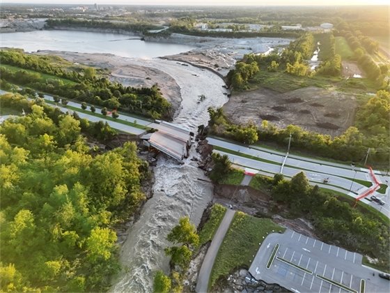
The Hazel Dell Parkway bridge near 106th Street, washed out after floodwaters reversed Blue Woods Creek into the quarry. Photo courtesy of the City of Carmel, used with permission, August 18, 2026.
The author used Anthropic's Claude for source retrieval, calculation, and drafting assistance. All assumptions, methodology, and conclusions are the author's own.1
The Event
In August 2026, storms dropped more than eleven inches of rain on parts of central Indiana in two days. The White River crested at 24.6 feet in Noblesville, breaking a record standing since 1913.2 Downstream in Carmel (known as the capital of roundabouts), floodwaters washed out the Hazel Dell Parkway bridge near 106th Street and did something stranger: they reversed the creek. Blue Woods Creek, which normally drains toward the river, began running backward — directly into an active limestone quarry.
The pit holds roughly nine billion gallons, which officials translated for the public as about 13,000 Olympic swimming pools. Within just a few days, nearly all of that capacity was gone. The bridge was declared a total loss, with replacement estimated at roughly $10 million and at least two years.3
For several days the situation was dangerous. A sanitary force main carrying about ninety percent of Carmel's wastewater ran through the erosion zone; the odds of a breach were at ninety percent. That was averted through an emergency stabilization barrier built overnight from sycamore trees, more than 140 loads of concrete, and sandbags placed with Indiana National Guard helicopter support.4
The emergency was handled. What remains is a valuation problem, and an unusually instructive one.
Why a Flooded Quarry Is an Appraisal Story
Not everyone reading this values mineral property for a living. So it is worth being explicit about why this is more than a local news item: it touches three ideas central to how mineral extraction properties are valued in acquisition and right-of-way work.
Highest and best use can be taken away without anyone taking anything
Highest and best use (HBU) is the appraiser's judgment about the most profitable legal use a property can reasonably be put to. It is the foundation of the value estimate, because value follows use. A quarry's HBU is likely mining, and its worth flows from that: tonnage in the ground, years of production left, the price of stone.
In right-of-way, enormous energy is spent arguing whether an acquisition changed a property's HBU — whether taking a strip of land cut off the access, the depth, or the permit that made the profitable use possible. Those arguments are almost always hypothetical: what would the property have done, absent the project? Here a flood did the thing we normally have to imagine. Mining stopped. Whether it resumes is now an open economic question rather than a settled fact; a forced change in highest and best use, in public, in real time, with no condemning authority in the picture.
Real property data, not guesswork
The data behind ParcelComp's comp searches comes from verified statewide records, the same discipline applied to every figure in this analysis. Try it free at parcelcomp.com.
Try ParcelComp →Establishing the Before-Value
Any before-and-after analysis needs a before. The Mine Safety and Health Administration (MSHA) publishes employee hours for every permitted mine in the country, but for metal and nonmetal operations it does not publish tonnage — so production must be derived rather than looked up. Reported hours for this operation (totaling 98,498, inclusive of all mine labor for surface and underground) works out to roughly 47 full-time equivalents and is consistent with the forty-plus displaced workers reported after the flood.5
Applying an operating rate of 20 short tons per man-hour yields annual production of approximately 1.97 million tons.6 For pricing, USGS reports a 2025 average unit value for crushed stone of $16.78 per short ton ($18.50 per metric ton).78
What is being valued, and what is not
A point of scope before the numbers. The land here is owned by the operator, not leased from a third party, so there is likely no royalty actually being paid to anyone. The royalty used below is a valuation device, not a contract term.9 It is the conventional way appraisers isolate the income attributable to the mineral in the ground from the income attributable to the business that extracts it — the plant, the fleet, the crews, the customer relationships, the hauling contracts.
That distinction matters. This is not a going-concern or business valuation. Nothing here attempts to value the operating enterprise, its equipment, or its contracts. What is being valued is real property: the land and the mineral beneath it.
Capitalizing a hypothetical royalty is how that separation gets made in practice — and readers who work partial takings will recognize it as the same move made whenever the unit rule requires the mineral interest to be valued as part of the land rather than as a business.
| Input | Value and Basis |
|---|---|
| Reported employee hours | 98,498 (MSHA) |
| Operating rate | 20 short tons / man-hour (derived) |
| Derived annual production | 1.97 million short tons |
| Average unit value | $16.78 / short ton (USGS, 2025) |
| Remaining reserve life | 15 years (assumed) |
| Discount rate | 8% real (assumed) |
| Residual land value after reclamation | $6 million (assumed) |
| Reclamation cost | $3 million (assumed) |
Annual royalty income is $1.97 million; discounted over fifteen years at 8 percent, the royalty stream is worth about $16.86 million.
Two further components complete the picture, and they are where the reclamation-timing effect lives. The residual land arrives fifteen years out, so its present value is $6 million discounted fifteen years, or $1.89 million. The reclamation cost is likewise deferred, so its present value is $3 million discounted fifteen years, or $0.95 million. Note how small that liability looks today: a $3 million obligation weighs less than a million dollars in present terms precisely because it is far away.
| Before-Value Component | Present Value |
|---|---|
| PV of royalty stream, 15 years at 8% | $16.86 million |
| PV of residual land, deferred 15 years | + $1.89 million |
| PV of reclamation cost, deferred 15 years | − $0.95 million |
| BEFORE VALUE (illustrative) | $17.81 million |
Call it approximately $17.8 million. Both scenarios below are a departure from that figure, built from the same components so the comparisons hold.
The Highest and Best Use Question
Two candidate uses now compete for this property (arguably more potential HBUs can be derived). They are genuinely competing — neither is obviously correct — and the analysis that follows is really an argument about which one a hypothetical buyer would pay the most for.
Simple closure is not among them. Walking away and reclaiming the site is an operational decision, not a highest and best use conclusion — it describes what an owner might do rather than the most profitable use the property supports. Reclamation appears below as a cost inside both paths, which is where it belongs.10
Path A: Restore Mining
The instinctive reaction to a flooded pit is that industrial pumps are powerful and the water will be gone by spring. However, pump capacity is not the constraint — the constraint is how much water may lawfully be discharged, and where it can go.
Indiana's general permit for quarry dewatering does not set a gallons-per-minute ceiling — it requires flow to be reported, and limits water quality instead.11 So the binding limit is treatment capacity: how fast water can move through sedimentation basins and still settle out below the statutory limits. That is a physical question about basin sizing, not an administrative allowance.
There are two complications; the first is what the water now contains. Fuel tanks, hydraulic equipment, and solvents are ordinary features of a working quarry, and the floodwaters arrived fast. Coverage under the general permit does not extend to discharges commingled with hazardous materials.12
The second complication is where the water goes. The site's outfall discharges to Blue Woods Creek — the same creek that reversed and cut the erosion channel that started all of this. Until that channel is rebuilt into a stable, one-directional watercourse, pumped water has nowhere reliable to go.
How long, and at what cost
Assume sustained discharge somewhere between 2,000–4,000 gallons per minute (a plausible order of magnitude for a treatment-limited outfall into a modest creek). The duration follows arithmetically:
| Sustained rate | Volume / day | Time to empty 9B gallons |
|---|---|---|
| 2,000 gpm | 2.9 million gal | 8.6 years |
| 3,000 gpm | 4.3 million gal | 5.7 years |
| 4,000 gpm | 5.8 million gal | 4.3 years |
Moving nine billion gallons takes roughly 6.6 million kilowatt-hours — an electricity bill of about $530,000 to $790,000 at industrial rates.13 Against an $18 million asset, the power to move the water is a rounding error. The expensive part of dewatering a quarry is not the pumping.
What actually costs money
- Pumps and installation. At multi-year duration, purchase beats rental — rental at roughly $3,000 to $6,000 per month per unit stops making sense past about eighteen months.
- Power infrastructure. Three-phase service, transformers, motor control center, distribution. Frequently larger than the pumps themselves.
- Outfall and channel reconstruction. Front-loaded, unavoidable, and it must precede pumping rather than accompany it.
- Treatment. Settling basins are inexpensive. If contamination requires oil-water separation plus activated carbon, treating nine billion gallons through carbon media is likely cost-prohibitive on its own — plausibly the single decision point that ends the mining case outright.
- Compliance and carrying costs. Sampling, laboratory work, monitoring reports, permits, bonding, taxes, and security across six to ten years of producing nothing.
Path A value scenarios
Deferring the entire before-value package pushes everything further out. Dewatering costs are modeled as spread evenly across the pumping period and discounted accordingly.14
| Scenario | Delay | Deferred base | Less costs | Value |
|---|---|---|---|---|
| A-1 Favorable | 4.3 yrs | $12.79M | $2.46M | $10.33M |
| A-2 Central | 5.7 yrs | $11.48M | $3.89M | $7.59M |
| A-3 Adverse | 8.6 yrs | $9.19M | $5.63M | $3.56M |
The spread is the story. Holding the reserve, the stone price, and the reclamation obligation constant — changing nothing but how fast water can lawfully leave the site — value ranges from roughly $10.3 million down to $3.6 million. Nearly two-thirds of the asset's value turns on a variable that has nothing to do with the deposit.
Restoration survives across the range, but it thins quickly. Each additional year of dewatering costs both ways: it defers the entire income stream and it adds another year of pumping, treatment, and compliance expense. Past roughly six years the two effects together have consumed more than half the property's value, and mining's claim to being the highest and best use gets progressively harder to defend — even though every ton of stone remains exactly where it was.
Path B: Water Storage
The second path is the one most likely to be dismissed as wishful, and the one where Indiana context makes it least dismissible. But it starts with a legal constraint that surprises appraisers trained in western markets.
You cannot sell the water
Indiana is a riparian state, not a prior-appropriation state. Landowners adjoining a watercourse hold a right to reasonable use, and those rights cannot be sold or transferred other than with the adjoining land.15 The practical consequence is significant: there is no severable water estate to appraise. You cannot value nine billion gallons as a commodity, cannot capitalize a water royalty, and cannot treat the water like a mineral interest surviving separately from the fee. Whatever value exists must be captured through the land and the storage structure — which turns the problem back into real estate.
The comparable sits ten miles away
Central Indiana has already run this experiment. A reservoir in Fishers is a retired limestone quarry, 230 feet deep and roughly 90 acres, converted to dedicated water storage and operational in late 2020, holding more than three billion gallons. A regional water provider acquired it in 2015 and negotiated an agreement permitting the prior operator to continue mining until spring 2019 before conversion began.16
That transaction structure is directly on point — a mineral operator winding down a reserve, a utility acquiring the void, and a negotiated period of continued extraction. It is also priced: the recorded consideration was $13.7 million for 90.7 acres, or about $151,000 per acre in 2015, equating to roughly $210,000 per acre in current dollars. On a storage basis that is approximately half a cent per gallon, adjusting to about six-tenths of a cent today.
Scale favors the subject substantially. At nine billion gallons the Carmel pit is nearly triple the Fishers reservoir and larger than the well known local Geist Reservoir — it would be the largest single water storage asset in central Indiana. The regional water provider's own water operations executive has framed the economics plainly: a conventional new reservoir costs $400 to $500 million, while quarry conversion runs five to ten cents on the dollar.17 Ten percent of $450 million is $45 million, which independently brackets what the transaction-based math produces.
Demand is real and already contracted
The same regional water provider formed a subsidiary to supply a nearby district in Boone County, with an initial request of six million gallons per day by 2026 and ten million by 2027, via an estimated $200 million pipeline and booster station project. A data center under construction in Lebanon is projected to use up to eight million gallons per day by 2031, and a gas-fired plant serving regional data centers is estimated at up to 33 million gallons per day.18 That $200 million figure is the useful anchor: it is what a utility was willing to spend on infrastructure to move water it already had. A buyer facing that cost structure cannot manufacture a nine-billion-gallon void at any price, because the void is the product of decades of extraction that will not be repeated.
Path B value scenarios
Here the appraisal problem is not arithmetic but market thinness. There is essentially one buyer class (a regulated utility or a public agency) and if it does not appear, the property falls back to land value with modest waterfront upside. The honest treatment is probabilistic rather than a single point estimate. A sale to a utility is estimated at $40 million; that figure is then weighted by the likelihood such a buyer actually materializes.19
| Scenario B (Water Utility) | Probability | Value if Sold | Risk-Adjusted Value |
|---|---|---|---|
| Pessimistic | 15% | $40M | $6.00M |
| Median | 25% | $40M | $10.00M |
| Optimistic | 40% | $40M | $16.00M |
The right-hand column is simply the sale price multiplied by its probability — what a buyer would rationally pay for the chance at that outcome. It assigns nothing to the case where no utility appears, which understates the path, since the property would still hold land and waterfront value. That omission is deliberate and keeps the comparison conservative.
The $40 million figure is stated net of reclamation, and this is where the timing principle does its work. Conversion ends mining now, which pulls the $3 million reclamation obligation forward from fifteen years out. Its present value rises from $0.95 million to the full $3 million — a $2.05 million swing created by nothing but the calendar. No additional work is performed. The same dirt gets moved. It simply gets moved now.
Two further observations. The probability weighting matters more than the high-side estimate: moving from a 15 percent to a 40 percent chance of a utility buyer nearly triples risk-adjusted value, while the $40 million figure could be wrong by a quarter without changing the ranking. And this is precisely the situation in which an appraiser should resist adopting the most exciting HBU. A nine-billion-gallon reservoir is a compelling story. Compelling stories with one potential buyer require heavy discounting.
See the underlying data yourself
ParcelComp filters Indiana's statewide SDF dataset by county, property class, date range, and arm's-length status — the same discipline behind every figure in this analysis, applied to real estate transactions across all 92 counties.
Try ParcelComp →The Two Paths Side by Side
| A. Restore Mining | B. Water Storage | |
|---|---|---|
| Low | $3.56M | $6.00M |
| Central | $7.59M | $10.00M |
| High | $10.33M | $16.00M |
| vs. $17.8M before | −42% to −80% | −66% to −10% |
| Dominant variable | How fast water can leave | Whether a buyer exists |
| Who controls it | Treatment capacity & IDEM | The market |
On these inputs the two paths interleave rather than separate. Favorable restoration ($10.3 million) beats median conversion ($10.0 million). Median restoration ($7.6 million) beats pessimistic conversion ($6.0 million). Only at the extremes does either path clearly win: optimistic conversion is the best outcome available, and adverse restoration is the worst. Anyone reaching a confident conclusion between these two on this record would be claiming more than the evidence supports.
What the comparison does establish is which questions matter. Mining's value turns almost entirely on the dewatering timeline; conversion's turns almost entirely on whether a buyer exists. Those are researchable questions with real answers — a discharge monitoring record and a conversation with a utility would move this analysis further than any amount of additional modeling. However, that conclusion rests on inputs a working appraiser would need to support with local evidence.
What the Case Teaches
Time is the dominant cost. Moving nine billion gallons costs perhaps $800,000 in electricity. Waiting for it to move costs six to nine million in foregone present value, and the delay is what erodes a recoverable reserve into a marginal one. When an event interrupts a finite income stream, the first question is not what the fix costs but how long it takes.
Acceleration is compensable value. The reclamation obligation did not grow. It arrived early, and that alone moved two million dollars. In partial-taking work, timing arguments deserve more rigor than they typically receive.
A depleting asset cannot wait. For most real estate, interruption and destruction differ in kind — a building that sits empty five years is still a building. For an asset whose income stream has a fixed end date, a long enough interruption is destruction, arriving quietly and without anyone removing a single ton of stone.
And the whole analysis was built from federally reported employee hours, a USGS price table, a state land office rate schedule, a county parcel record, and a state permit — no operator cooperation required.20 That is worth remembering the next time a file lands with no access and a deadline attached.
This article and exercise is a demonstration of a defensible analytical structure built entirely from public records. It was written in the weeks following the flood; this is an on-going event and subject to a set of everchanging facts.
Sources & Notes
- Artificial intelligence disclosure. Anthropic's Claude was used in preparing this article to locate and retrieve public-source documents, perform present-value and unit-conversion calculations, and produce and revise drafts. All methodology decisions, assumption selections, and analytical conclusions are the author's, as is responsibility for the content. Source documents were identified with AI assistance and are cited so readers may verify them directly.
- National Weather Service, central Indiana flood summary, August 2026; river stage via USGS gauge at Noblesville.
- City of Carmel press conferences, August 17–18, 2026, reported by WISH-TV, WRTV, and Current in Carmel. Bridge replacement cost and timeline attributed to Hamilton County. Job losses reported by WTHR, August 20, 2026.
- IndyStar and NewsNation, August 19, 2026; WISH-TV, August 18, 2026; City of Carmel press release, August 19, 2026.
- MSHA Mine Data Retrieval System. Metal and nonmetal operations report employee hours but not production tonnage, so production must be derived.
- Derived by applying 20 short tons per man-hour to reported MSHA hours. The Indiana Mineral Aggregates Association reports statewide annual production of approximately 45.2 million metric tons of crushed stone and 17.4 million metric tons of sand and gravel against more than 4.5 million logged hours (2018), which converts to roughly 15.3 short tons per man-hour blended across both commodities. Because sand and gravel operations are typically smaller and less productive per hour, isolating crushed stone raises the implied rate to roughly 17 to 20 tons per man-hour blended at the upper end of that band, consistent with a large, well-capitalized operation, and is the author's judgment. Underlying data: MSHA Mine Data Retrieval System and USGS Aggregates Time Series 1971–2023 Data by State, Type, and End Use, both compiled at NSSGA, Data by State.
- USGS Mineral Commodity Summaries 2026, Stone (Crushed), prepared by J.C. Willett, February 2026. Average unit value reported at $18.50 per metric ton (2025 estimate), converted 1.10231 short tons per metric ton. USGS notes price pressure was expected to continue in 2026, particularly in and near metropolitan areas where zoning and land-development alternatives push new quarries away from population centers.
- Aggregate is not a leasable mineral federally; under the Materials Act of 1947 the Bureau of Land Management sells sand, stone, gravel, and clay at fair market value rather than leasing for a royalty, and notes its sale contracts generally require only a few dollars or less per ton. For a published governmental rate schedule, the New Mexico State Land Office lists negotiated royalties on state land per ton across three aggregate categories; the middle figure is adopted here. Royalty rates are not transferable between properties: they are driven by material quality, deposit characteristics, haul distance, market access, lease term, and localized conditions, and there is no single prevailing rate for limestone or for sand and gravel. The figure used here is a published governmental benchmark selected to avoid overstating the mining case, not an estimate of what this or any other deposit would command, and no inference should be drawn from it as to rates prevailing in any private market.
- Public records indicate the operator holds fee title to the subject land rather than a leasehold, so the royalty applied here is hypothetical and used solely to isolate the value of the mineral interest. Researchers seeking evidence of rates the operator pays where it does lease reserves may find disclosure in its Form 10-K and related SEC filings; that avenue was not pursued for this article and is noted as a line of inquiry rather than a source relied upon.
- Discount rate, remaining reserve life, residual land value, and reclamation cost are the author's assumptions, selected as round figures for illustration and not derived from operator data.
- NPDES general permit ING490000 for sand, gravel, dimension stone, and crushed stone operations, effective October 1, 2025. The permit requires discharge flow to be reported rather than capped; the only numeric effluent limits are total suspended solids at 30 mg/l daily maximum and pH between 6.0 and 9.0.
- ING490000 does not authorize discharges commingled with hazardous wastes or hazardous materials. Indiana's spill rule is at 327 IAC 2-6.1. IDEM may require an individual permit where circumstances have changed such that a discharger is no longer appropriately controlled under the general permit, or where a discharge is a significant contributor of pollutants, expressly considering discharge volume.
- Author's calculation. At 3,000 gallons per minute against an assumed 150 feet of total dynamic head, brake horsepower computed as flow times head divided by 3,960 times pump efficiency, at 70 percent pump and 92 percent motor efficiency, yields approximately 162 brake horsepower, or roughly 0.73 kilowatt-hours per thousand gallons moved. The discharge rate range is an assumption, not a permit term.
- Dewatering cost estimates are the author's, covering pumps, power infrastructure, outfall and channel reconstruction, treatment, and multi-year compliance. They are order-of-magnitude figures intended to demonstrate structure.
- Riparian doctrine; see Indiana Code 14-25-1-3, surface water as public water subject to state regulation. Contrast with prior-appropriation states noted in Purdue University agricultural and biological engineering faculty commentary, 2025.
- Citizens Energy Group; Indiana University Environmental Resilience Institute case study. Acquired 2015 from Marisa Limited Partnerships, with an agreement permitting Irving Materials to continue mining until spring 2019. Hamilton County parcel 29-15-02-000-046.006-020; recorded consideration $13.7 million for 90.7 acres, or $151,047 per acre, equating to roughly $210,000 per acre adjusted to current dollars at approximately 39 percent cumulative CPI-U change.
- Citizens Energy Group vice president of water operations Jeff Willman, stating a conventional reservoir costs $400 million to $500 million and that quarry conversion runs 5 to 10 cents on the dollar by comparison.
- Inside INdiana Business, 2023, for LEAP district supply, Citizens Water Resources Holdings, and the estimated $200 million project including 33 miles of pipeline and three booster stations. Citizens Action Coalition, 2026, for Lebanon data center and gas-fired plant water projections. Significant Water Withdrawal Facility registration threshold at Indiana Code 14-25-7.
- The $40 million figure is derived from the Fishers transaction on a per-gallon-of-storage basis, adjusted to current dollars and discounted for diminishing marginal utility of storage beyond a buyer's requirement, for condition differential, and for absence of an existing system connection. It is stated net of accelerated reclamation cost. Probability weightings are the author's judgment. Note that this treatment assigns no value to the outcome in which no utility buyer appears; in that case the property would retain residual land value with modest waterfront or recreational upside. Excluding it understates Path B and is deliberately conservative.
- The author has no financial interest in the operator, the regional water provider, the subject property, or any party to the events described. No operator data, reserve reports, permits, or financial records were accessed. Nothing here constitutes an appraisal, an opinion of value, or legal advice.